On a January morning, Jennifer and I wake up early and hurry to the tip of Wisconsin Point – a three mile long natural sand spit reaching out into Lake Superior and separating this great lake from the Duluth-Superior harbor. Wisconsin Point, along with its twin, Minnesota Point, make up one of the longest freshwater sandbars in the world.
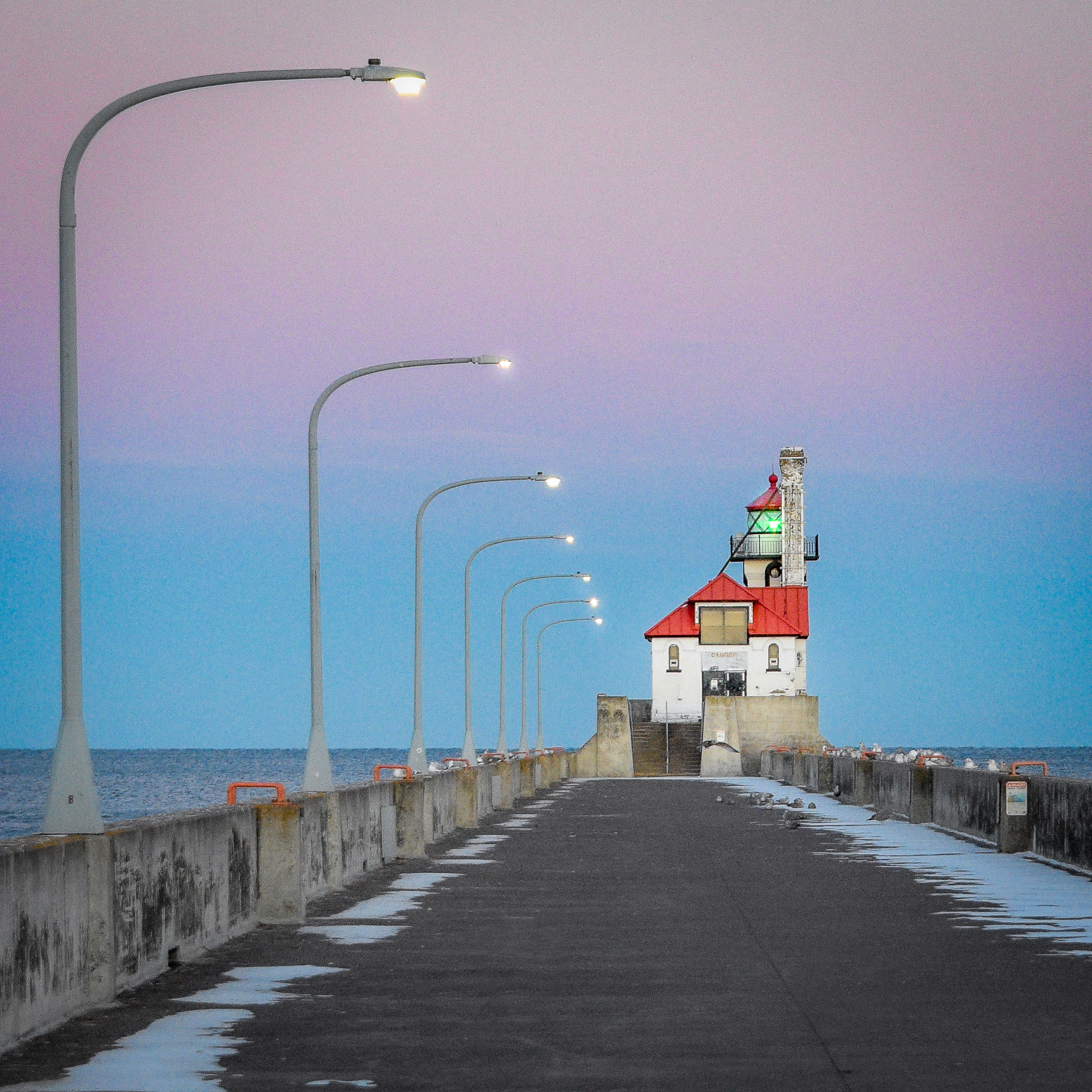
The Wisconsin Point Lighthouse stands at the threshold of Superior Harbor, its red roof a beacon between cold winter sky and concrete. The breakwater draws a quiet boundary between Lake Superior and a working harbor that’s closing in with ice.
However, geography is not our focus this morning. Instead, we’re here to meet the Great Lakes Freighter, John Munson, as it comes into port for a the winter layup.
The freighter, John Munson, enters the Duluth-Superior Harbor for winter layup, her long hull easing past Wisconsin Point through the cold, gray water of Lake Superior. Built for motion and brute force, the ship slows now to an idle as it glides towards a long pause for ice.
Iron and diesel -
tools of a revolution,
give way to water
The Fred A. Busse was a City of Chicago Fireboat placed into service May 4, 1937. At the time, it was the largest diesel powered fireboat in the world. She retired from the Fire Department in 1981 and is now located at the Door County Maritime Museum in Sturgeon Bay, Wisconsin on the scenic Door Peninsula. The historic, and iconic, iron bridge is in the background.A male Cardinal in the Wisconsin winterAt the edge of water and ice, the Wisconsin Point Light keeps a quiet watch over Lake Superior in winter. It has guided ships since 1913 through the narrow passage between the greatest of lakes and busy ports of Duluth and Superior.
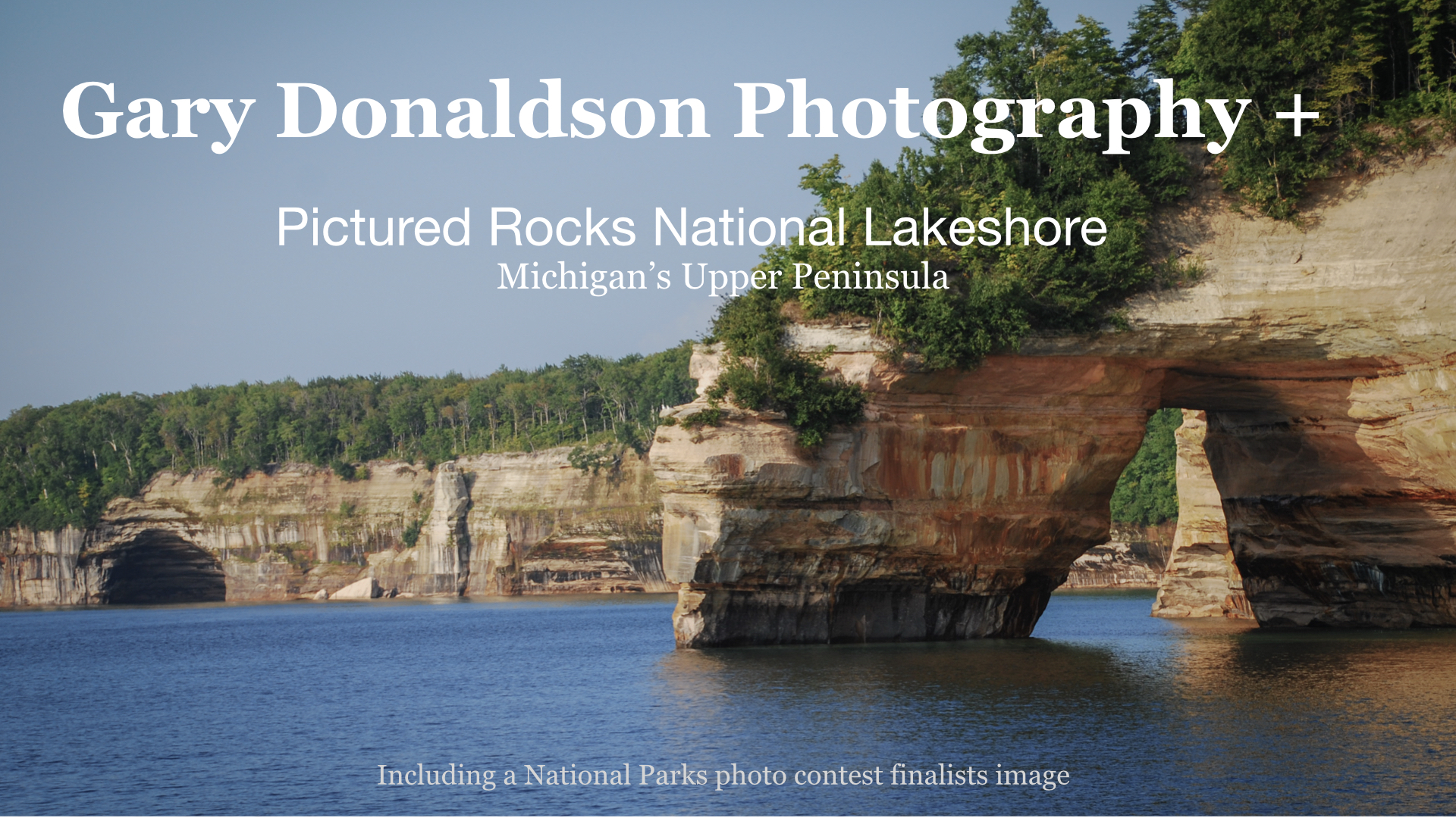
Stretching for 42 miles along the southern shore of Lake Superior in Michigan’s Upper Peninsula, is a landscape carved by time, water, and wind. Towering sandstone cliffs rise dramatically above the turquoise waters of Lake Superior. The cliffs, are painted in layers of red, orange, green, and gold by mineral-rich groundwater seeping through the rock. The result is a geological canvas of color and texture. It constantly shifts as light plays off the moody waters of Lake Superior. It’s a dream location for photographers! And for all visitors, alike.
Note – All images in this post are “clickable”. Click on smaller images to view them larger. Click on larger images to view them smaller.
Sandstone cliffs glowing at sunrise
Sea caves at Pictured Rocks National Lakeshore
Carved by relentless waves, these cathedral-like arches echo with the voice of Lake Superior
Designated as America’s first National Lakeshore in 1966, Pictured Rocks offers an amazing array of options for exploration. Whether arriving by hiking trail, kayak, or boat, the park invites you to slow down. Breathe in the crisp northern air. Take in the wild beauty of one of the Midwest’s most unique landscapes.
The Boreal Forest
Golden evening light spills through the pines, tracing shadows across the sandy bluffs where forest
meets lake.Inside the boreal forest, a fragrant world of spruce, birch, and shadowed understory thrives beneath the filtered northern light
To Learn more about the boreal forest of Michigan’s Upper Peninsula, click, HERE.
Sea Stacks, Rocks, and Waterfalls
Future sea stacksLarge fallen rocks along the shoreline stand like a family waiting for the sunsetFrom forest to stone to lake, cold streams plunge over sandstone ledges into the greatest of lakes
Chapel Rock
Chapel Rock is a sandstone sea stack at Pictured Rocks. This iconic formation is adorned by a famous 250 years old white pine tree perched atop the stack. It continues to survive thanks to its remarkable roots. These roots reach back to the mainland even after the connecting arch collapsed in the 1940s!
To visit this beacon of strength and determination in person, you can take the Chapel Rock and Chapel Beach Trail. It offers a scenic hiking experience. It is about a 6.2-mile round trip. An easy way to admire the park is from the water by kayak or boat tours.
Geology of Pictured Rocks National Lakeshore
Take a deep dive into the geological origins of this location, by clicking HERE.
The image that earned a finalist position with the National Parks, Share the Experience, Photo Contest
Chosen as one of the month’s best images by the National Park Service, this scene captures two kayakers surrounded by the amazing artistry of Pictured Rocks
I never thought of this as the best image from the trip, but there is something special about it. Two kayakers share an unforgettable moment, dwarfed by the towering sandstone cliffs of Pictured Rocks. The vivid, vertical strokes of mineral-stained color flow behind them. It looks like nature’s abstract painting. The bright yellow kayak slices horizontally across the glowing water. It’s a bold contrast of motion against painted stone. I intentionally left out the skyline, causing the scene to feel immersive and timeless.
I had no expectations when submitting the image to the National Park Service’s monthly photo selection. However, within a day, I received a reply containing a single word: “Beautiful.”
To my surprise, the photo was ultimately chosen as one of the best images of the month, joining a group of just 11 images selected from tens of thousands of submissions. The top three photographers earned handsome prizes. I received a one-year pass to all federal lands as a nice consolation.
I wasn’t surprised or disappointed . The other winning images were extraordinary: high-quality, professional, National Geographic- looking. My photo wasn’t technically perfect, but it offered something unique. It showed a moment of two people sharing an unforgettable experience beneath one of America’s most striking landscapes, within an intriguing composition. For that reason, I think it punched above its weight class.
Sunset from Pictured Rocks National Lakeshore
Take some time to immerse in yourself in this image.
Breathe. Relax. Dream. Go!
Evening settles over Lake Superior as fading sunlight radiates across calm water. Sky and water speaking for the setting sun
Support
Did you enjoy this post? Do you appreciate what I’m striving to accomplish with the photo essays and stories? If yes, I encourage you to subscribe below. Subscriptions help my site gain traction with a broader audience.
Your information is encrypted and protected. I’ve declined all offers to advertise on this site.
I would like to introduce you to my new camera – The Ricoh GR IIIx. A compact, premium camera known for It’s sharp 40mm fixed lens. Designed for street and travel photography, it delivers exceptional image quality in a pocket camera that actually fits into a pocket – or discretely in my dinner plate-size hands.
I’ve been putting it through its paces over the last week in situations where having a full-size camera is either too bulky for the situation or too conspicuous. This is my first step outside the Nikon family of cameras and I can report having a lot of fun with it. I’m impressed with the performance, so far.
Nightscape – Downtown Minneapolis
Making it Yours
This camera is highly customizable. The user is able to tailor the camera to individual shooting styles, from street photography and quick travel snapshots to deliberate, composed landscapes and portraits. Multiple user modes allow instant recall of the pre-designed shooting settings, eliminating the frustration of fumbling through pages of settings while the subject has sauntered away from the scene. Also, people react differently to a (seemingly) simple pocket camera than to the sophisticated, serious looking full-size camera.
Morning Reflections – Downtown Minneapolis
Going Stealth Without Sacrificing Quality
The combination of discrete portability and shooting style personalization makes the RicohGR IIIx a great addition to my modest stable of cameras. I’ll keep you posted on how this new camera works out for my photography style.
Note
The image of Purple Loosestrife on the Yellow River in the previous post, The River that Whispers, was also captured with the Ricoh GR IIIx.
And as I anticipated, some folks on a Facebook group couldn’t reconcile the fact that something so vile and hated as the highly invasive Purple Loosestrife could, at the same time, be so beautiful. Oh well, I understand.
Today I took a drive up Minnesota’s north shore of Lake Superior. I was hoping to get a photograph of an Owl(s) not commonly seen in this area. In recent weeks, species such as the Boreal, Snowy, Great Gray, and the Northern Hawk Owl have been migrating. They are moving from their winter habitat in the Canadian Shield into northeastern Minnesota. This movement is known as an irruption. However, I was in for an unexpected[ wildlife encounter.
Irruption
The irruption (not eruption) of owls involves a sudden and irregular migration. This usually happens due to natural cycles in prey populations. When there is lack of common prey in Canada, these owls move south in search of food. The phenomenon can occur every few years to decades apart.
I drove all the way to Two Harbors, Minnesota without seeing a single owl. On the way back to Duluth-Superior area, I stopped at a coffee shop. I had been wanting to check it out. The owner advised taking the 4-lane highway back. He said to keep an eye on the grassy medium and check the berm areas for owls. He also mentioned taking a few side roads for a mile, or so, then back to the highway.
The unexpected encounter
For miles I saw no owls. I decided to take one side road before giving up and heading back home. A few hundreds yard down the road a slight movement caught my eye. I stopped and I glanced quickly towards the movement. The Gray Wolf in the featured image above was watching me intently. I quickly grabbed the camera a snapped a couple of photos without worrying about the settings – hoping for the best. I looked down at the camera to change the settings to manual focus. When I looked up, the wolf was gone.
I said to myself, Well, I came looking for owls and found a Gray Wolf. I’ll take it!
A Boreal Owl sitting on a branch is highlighted by rays of evening sun. this image is AI generated.
An ocean-going freighter enters the Duluth Harbor. In this situation, the vessel is called a, “Salty.” It will eventually exit the Great Lakes through the St. Lawrence Seaway and into the North Atlantic. Freighters of the Great Lakes play a crucial role in connecting inland ports to the rest of the world.
Freighters that stay within the Great Lakes are, “Lakers,” making them part of the unique freighters of the Great Lakes.
The Port of Duluth-Superior
The Port of Duluth-Superior is the farthest inland seaport in the world. Situated at the westernmost point of all of the Great Lakes, it is approximately 2,340 miles to the Atlantic Ocean.
This photo is from the vantage point of the Duluth Lakewalk. It is near the Lake Superior Maritime Visitor Center in Canal Park, Duluth, Minnesota. This area offers a great view of the freighters of the Great Lakes. This is a wonderful place to visit. We’ll be exploring it in more detail in future posts.
When examining a map, the significance of the Port of Duluth-Superior becomes evident. It is crucial to the Iron Ranges of Minnesota and the grain farmers of the Midwest. It provides them, and other industries, access to the world markets.
The historic Duluth South Breakwater Lighthouse is located at the southern end of the Duluth Shipping Canal in Duluth, Minnesota. This iconic structure stands at the entrance to the busy Duluth-Superior Harbor. It has guided ships into the harbor since 1901.
The Duluth South Breakwater Light and the North Breakwater with its own light formed a passage for ships. This passage allowed entry or exit from Lake Superior. These navigational lights played a vital role in the growth of commerce and shipping in the region. Duluth’s position as a key port on the Great Lakes was crucial. It experienced a significant flow of iron ore, coal, and grain. The South Light carried a fourth-order Fresnel lens and a foghorn. The combination helped ships navigate safely into the harbor during snowstorms and heavy fog.
The South Breakwater Light was decommissioned in 2006 due to continued advances in maritime navigation. Yet, it remains an enduring landmark for the Duluth/Superior area. It reflects the broader story of Great Lakes navigation. It’s light still directs us to the industrial revolution of the late 19th and early 20th centuries. Today, the light is listed on the National Register of Historic places. It preserves its legacy as a beacon of safety. It stands as a testament to the area’s rich maritime history.